
WESTPAC
Jump to: Mission Objectives, Mission Instrumentation, Mission Parameters, Additional Information
Mission Photos:
Courtesy of EOS
Mission Objectives:
At the Western Pacific Laser Tracking Network (WPLTN) Executive meeting in Moscow on 2 December 1995, it was announced that Electro Optic Systems (EOS) had entered into a joint project with the Russian Space Agency (RSA) to construct and launch a new SLR satellite (WESTPAC-1, formely known as WPLTN-1) designed to overcome the limitations of all present targets in relation to millimeter geodesy. The satellite has a very similar in design to GFZ-1.
The main immediate purpose of the satellite is to provide the best possible target for the WPLTN stations and, by implication, the Keystone Project constructed by Communications Research Laboratory (CRL) of the Japanese Ministry of Posts and Telecommunications.
More detailed information on the WESTPAC satellite can be found in the WESTPAC Satellite Scientific-Technical Note for User document developed by The Russian Institute for Space Device Engineering and The Science Research Institute for Precision Device Engineering.
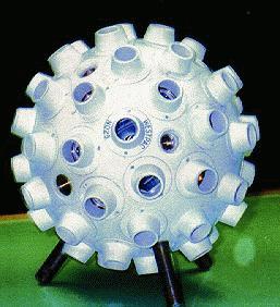
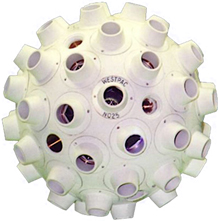
The WESTPAC satellite is covered with recessed retroreflectors of the Russian Fizeau design to permit only one retroreflector to contribute to the return. On average, 0.7 corner cubes contribute to the return, and therefore the return signal fades in and out as different reflectors come into view. The satellite is well-suited for advanced two color ranging experiments.
Mission Instrumentation:
WESTPAC is a passive satellite where the only instrumentation onboard is the retroreflector array.
Mission Parameters:
| Sponsor: | Western Pacific Laser Tracking Network |
| Expected Life: | decades |
| Primary Applications: | geodetic and retroreflector technology |
| COSPAR ID: | 9804305 |
| SIC Code: | 8801 |
| Satellite Catalog (NORAD) Number: | 25398* |
| Launch Date: | 10 July 1998 |
| RRA Diameter: | 24 cm |
| RRA Shape: | circular |
| Reflectors: | 60 corner cubes |
| Orbit: | circular, sun synchronous |
| Inclination: | 98 degrees |
| Eccentricity: | 0.0 |
| Perigee: | 835 km |
| Period: | 101 minutes |
| Weight: | 23 kg |
*Note: The satellite IDs for Westpac assigned at launch were 25394 (NORAD number) and 1998-043A (9804301, COSPAR ID). These designations changed sometime after launch in 1998 to 25398 (NORAD number) and 1998-043E (9804305, COSPAR ID). The ILRS originally elected to retain the old numbers for the duration of the original tracking period (1998-2002).
In 2024, the ILRS Network and Engineering Standing Committee (NESC) decided to initiate tracking tests on this satellite to evaluate the feasibility of resuming regular tracking of the satellite for science purposes. All CRD2 data and ancillary data (CPFs) must use the new designations for the NORAD number (25398) and COSPAR ID (1998-043E, 9804305) or else the data will be rejected by the Automatic Quality Control checks at the EDC and/or at the NASA SLR Data Operations Center.
Note: The satellite IDs for Westpac changed sometime after launch in 1998 to 25398 (NORAD number) and 1998-043E (COSPAR ID, 9804305). The ILRS elected to retain the old numbers (25394, NORAD number; 1998-043A, 9804301, COSPAR ID) for the duration of the original tracking period from 1998 to 2002.
Any new data submitted in CRD2 format should conform to the new designations for Westpac that are listed in this Mission Table.
Special Note
Message to stations for resumption of tracking of the WESTPAC satellite:
The ILRS Governing Board has approved resuming tracking of the WESTPAC mission. The GB believes there is scientific justification for readmitting WESTPAC to the ILRS target list because routine SLR measurements could complement the data from the existing geodetic targets, particularly for gravity field recovery, and could also provide atmospheric and range error information.
WESTPAC was launched on 10th July 1998 into a sun synchronous orbit at 835 km altitude, 98° inclination and near zero eccentricity. It was a joint project of Electro Optic Systems (EOS, Australia) and the Russian Space Agency (RSA). The satellite has a diameter of 245 mm, with 60 corner cubes and a mass of 23.757 kg. Each retro-reflector has a baffle tube 31.5 mm high that narrows the acceptance angle to 26° full angle. As a result, only a single cube at a time can be observed by SLR. This results in a zero-signature SLR target and a centre-of-mass offset can be modelled with an accuracy of 0.5 mm.
It was launched with a spin period of around of 3–6 seconds, but this has been reduced over the many years in orbit. This results in short periods during a satellite pass when no retro-reflector is visible to the SLR stations. ILRS support for WESTPAC ended in December 2002.
In 2024, the ILRS Network and Engineering Standing Committee (NESC) decided to initiate tracking tests on this satellite to evaluate the feasibility of resuming regular tracking of the satellite for science purposes.
The decommissioned geodetic satellite WESTPAC will be returned to the ILRS target list with a low priority, not resulting in a significant burden to station scheduling or impact on other priority targets.
ILRS stations have demonstrated that with good predictions it can be tracked routinely during the day and night, without a significant impact on their tracking schedules or at the expense of other ILRS targets.
The satellite IDs for WESTPAC assigned at launch were 25394 (NORAD number) and 1998-043A (9804301, COSPAR ID). These designations changed sometime after launch in 1998 to 25398 (NORAD number) and 1998-043E (9804305, COSPAR ID). The ILRS originally elected to retain the old numbers for the duration of the original tracking period (1998-2002).
CPF predictions have improved significantly since they became available and the time bias for the latest daily prediction can be expected to be as low as only a few milliseconds. This is very advantageous during daylight tracking and gives observers confidence to not search widely in along-track corrections, but to instead wait for a retro-reflector to be visible.
Daily predictions are currently provided by the Space Geodesy Facility, Herstmonceux and are available for download at the ILRS Data Centers.
We appreciate the Network’s support,
Regards,
ILRS CB
March 2025
Additional Information:
- Press release on Westpac satellite, July 17, 2019
Publications:
- Bloßfeld M., Rudenko S., Kehm A. et al. (2018). “Consistent estimation of geodetic parameters from SLR satellite constellation measurements”, J. Geodesy, 92, 1003–1021, doi: 10.1007/s00190-018-1166-7
- Burmistrov V.B., Parkhomenko N.N., Pliev L.F. et al. (1999). “The WESTPAC Satellite: Design Features and First Results of Return Signal Analysis”, in Proceedings of the 11th International Workshop on Laser Ranging, Deggendorf, Germany, September 21-25, 1998, (eds) Wolfgang Schlüter, Ulrich Schreiber, Reiner Dassing, Verlag des Bundesamtes für Kartographie und Geodäsie, pp. 297
- Glotov V., Mitrikas V, Revnivych S., Parkhomenko N. (1998). “WESTPAC satellite orbit parameters and measurements accuracy”, Proceedings of the 11th International Workshop on Laser Ranging, Deggendorf, Germany, Sept. 21-25, 1998
- Rutkowska M. and Noomen R. (2002). “Orbit analysis of the satellite Westpac”, Adv. Space Res., 30(2), 265–270, doi: 10.1016/S0273-1177(02)00294-6
- Rutkowska M. and Noomen R. (2000). “SLR systems characteristics in Westpac, LAGEOS-1 and LAGEOS-2 observations”, Proceedings of the 12th International Workshop on Laser Ranging, Matera, Italy, November 13–17, 2000
- Rutkowska M. (2005). “The accuracy of orbit estimation for the low-orbit satellites LARETS and WESTPAC”, Adv. Space Res., 36(3), 498–503, doi: 10.1016/j.asr.2005.04.063
- Surkov V.V. (2020). “Effect of Geomagnetic Field on Motion of Passive Conductive Satellites”, Geomagnetism and Aeronomy, 60, 192–204, doi: 10.1134/S0016793220020152
- Walker C., Barker B. (2000). “Atmosphere density corrections for differential correction and prediction in an operational environment”, AIAA/AAS Astrodynamics Specialist Conference, Denver, Colorado, 14–17 August, 2000, AIAA Paper 2000-3929, doi: 10.2514/6.2000-3929
- Zeitler, L., Corbin, A., Vielberg, K., et al. (2021). “Scale factors of the thermospheric density: A comparison of satellite laser ranging and accelerometer solutions”, J. Geophysical Research: Space Physics, 126, e2021JA029708, doi: 10.1029/2021JA029708

- NASA Official: Frank Lemoine
- Web Developers: 610 Web Dev
- Contact Us
- Last modified date: Sep 17, 2012
- Privacy Policy & Important Notices